Shake, Rattle, and Roll
Within the last few years, you’ve no doubt seen the devastation and destruction that can be caused by earthquakes. New Zealand, Haiti, Japan, China, Chile, and the Philippines are all places that have felt the earth violently shaking beneath their feet. But why these places? Why hasn’t something like this happened to us here in Massachusetts? We set out to do some research to find out!
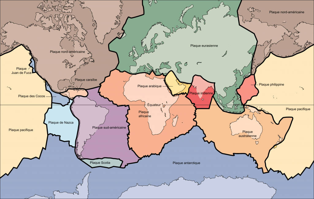
As we began to learn about Earth, we discovered that it is made up of many different layers, the crust, mantle, outer core, and inner core. The crust and the upper part of the mantle is often also referred to as the lithosphere. The lithosphere isn’t completely solid though. It’s actually broken up into many different pieces. We call these pieces tectonic plates. These plates fit together like puzzle pieces but rather than a puzzle that you may put together at home or school, these puzzle pieces are constantly moving, albeit very slowly. The location where these pieces meet is referred to as plate boundaries. Within these plate boundaries are faults, which is where earthquakes most commonly occur. The edges of these plates are rough so they sometimes get stuck against one another. Because the rest of the plate is moving while the edge is stuck, pressure builds up until they eventually break free causing the earth around it to shake, sending seismic waves to the surface and thus resulting in an earthquake.
As we began to learn about Earth, we discovered that it is made up of many different layers, the crust, mantle, outer core, and inner core. The crust and the upper part of the mantle is often also referred to as the lithosphere. The lithosphere isn’t completely solid though. It’s actually broken up into many different pieces. We call these pieces tectonic plates. These plates fit together like puzzle pieces but rather than a puzzle that you may put together at home or school, these puzzle pieces are constantly moving, albeit very slowly. The location where these pieces meet is referred to as plate boundaries. Within these plate boundaries are faults, which is where earthquakes most commonly occur. The edges of these plates are rough so they sometimes get stuck against one another. Because the rest of the plate is moving while the edge is stuck, pressure builds up until they eventually break free causing the earth around it to shake, sending seismic waves to the surface and thus resulting in an earthquake.

Once we learned about how earthquakes occur, we began to research where they tend to occur to see if they matched up with the information we had learned. Using the USGS website, we took a look at some of the larger earthquakes that have happened around the world the last couple years. Then, to see how their location compared to the plate boundaries shown in the image above, students worked with a partner to record data about each earthquake in a Google Spreadsheet. Each group recorded the location, including latitude and longitude, magnitude, depth, and a link to the webpage that they got their information from. Take a look down below to see the spreadsheet that Izzy and Luke created!
Once we finished putting our information into a Google Spreadsheet, we then turned our attention to the Google Maps Engine. The Google Maps Engine worked much better than Google Maps for this particular project because we were able to import our spreadsheet straight into the program and it automatically plotted our points! You can take a look right below to see the map that was created that accompanied Luke and Izzy’s spreadsheet.
Take a look at Luke and Izzy’s map and compare it to the picture of the location of the many plates across the Earth. Do you see any similarities? If so, share it with us in the comment section below!

Wow it looks like you have done alot of research, hope you enjoyed researching. Anyone could write and entire book about earthquakes with that amount of information. I have and edublog too, to go onto my blog look up “6rc” on the internet, press the first link, then you will be on my class blog but to go to my blog look on the side and scroll down until you see “Sarita” click “Sarita” and then you will be on my blog!
enjoy!